
3D scanning apps such as Scaniverse allow you to capture and share your world in exciting new ways. The ability to manipulate an object or navigate through a scene adds a level of physical presence that doesn’t exist in other media.
The physical nature of a 3D scan is closely tied to another attribute: its location in the world. The buildings, objects, and scenes that you scan exist in real places, and knowing where those places are can be an important part of the experience.
That’s why we’re pleased to announce that Scaniverse now supports saving, sharing, and exporting the location of your scans. Read on to learn more.
Saving & viewing location
Once you enable location, we’ll start saving the GPS coordinates of your scans. Pressing the “more” button in the upper-right corner of a scan will show you the location of your scan on a map, along with its latitude, longitude, and other scan metadata:
Sharing location
We’ve also added an option to include location when posting to Sketchfab. Switching it on will add a map pin like this one to the description:
When viewers of your scan click the link, they’ll be taken to a map showing its location. To see what this looks like, check out the scan below on Sketchfab.
Exporting location
Finally, we understand that location is an important part of many lidar workflows. To support these, we’ve added the ability to export georeferenced point clouds in the LAS format. Every point in the point cloud has UTM coordinates and elevation, and it’s straightforward to import these into GIS tools.
Privacy by design
Privacy has always been a priority for Scaniverse. All scan data is stored locally, and processing is performed on your device, not in the cloud. We’ve applied the same privacy-first design to location. Locations are stored locally and never leave your device unless you choose to share them.
We also realize there may be cases where you don’t want to save location at all, so we’ve made it easy to turn location on and off directly from the scanning screen.
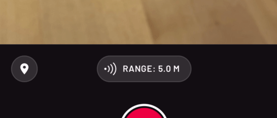
Location can be turned on and off by pressing the map marker button.
To recap, Scaniverse now lets you save location with your scans, share location when posting to Sketchfab, and export georeferenced point clouds.
You can try these features by downloading Scaniverse on the App Store today. Thanks for reading!